Driving the Dempster
A trip on this famous highway brought joy to an adventurous family

When my wife Chris and I decided to visit our daughter, Louise, and her partner Jon in Whitehorse, Yukon, going even further north was far from our minds. The five-day trip from Calgary and our drive on the Alaska Highway would be adventure enough, we figured.
Right after we got there, the thrill-seeking couple had other ideas, however. They wanted to hook our small A-frame trailer to their appropriately named Toyota Tundra and take us on the famous–maybe notorious–Dempster Highway to Inuvik, inside the Arctic Circle. How could we resist?
All they asked was for us to buy a second spare wheel for the trailer and a few days’ worth of food supplies. Jon built a contraption on his truck canopy to carry an extra four containers of gas and packed his special tire repair kit.
Off we went on a pleasant, mid-August morning to see a part of Canada that until then seemed inaccessible and even formidable. The next eight days gave us a glimpse into this awesome territory and a new appreciation for our immense country.
The two-lane, 736-kilometre Dempster Highway, Canada’s only all-weather road to cross the Arctic Circle, officially starts 484 kilometres from Whitehorse. Apart from the final asphalt entry into Inuvik, the road is gravel-surfaced the whole way.
A historic landscape
Completed in 1979 primarily for the energy industry after 20 years of planning and construction, the highway sits on top of a gravel berm of varying thicknesses, insulating the permafrost underneath. While the weather was mostly favourable, heavy rain on our return showed us how slippery and rutted the surface could quickly become. As the excellent Dempster Highway Travelogue guide we picked up in Whitehorse informed us, the road took us into a unique landscape, through a region that until 190 million years ago was the coastline of ancestral North America.
We were sharing the lands of the Han, Gwitch’in and Inuvialuit peoples, a point reinforced when my taking photos of a First Nations fishing camp by the Peel River prompted strict rebukes from inhabitants.
Expectations were high as we turned off the Klondike Highway from Whitehorse and fueled up. The next gas station would be at Eagle Plains, 369 kilometres further up the Dempster.
Our first overnight stay was in Tombstone Territorial Park, one of the most beautiful areas along the highway. We were in the tundra, a land of near-continuous permafrost covered by a thick and luxuriant layer of moss and lichens. Trails lead up the almost treeless valleys and to dramatically jagged peaks.
A moose from close-up and a bear on distant slopes were among the wildlife sightings we experienced. We decided to stay another night.
Driving the next day seemed relatively smooth, with most vehicles showing Dempster courtesy by slowing down and moving over when passing. On frequent stretches, though, we wouldn’t see another vehicle for half an hour. Referring to our guidebook, we learned about such things as tors, the odd-shaped pillars of rock resulting from frost shattering.
Reaching the next milestone
Our next camping stop was at Engineer Creek. The supply of Arctic grayling seemed endless in Jon’s catch-and-release routine.
The road, lined with dwarf spruce and tamarack, was a bit rougher as we climbed to the Eagle Plain Plateau, with its splendid views of the Richardson Mountains and the Ogilvies. A section of the highway even doubles as an airplane landing strip.
We succumbed to the temptation of burgers and fries at the supremely isolated Eagle Plains Hotel, proclaiming itself as a “chance to sample the amenities of civilization.”
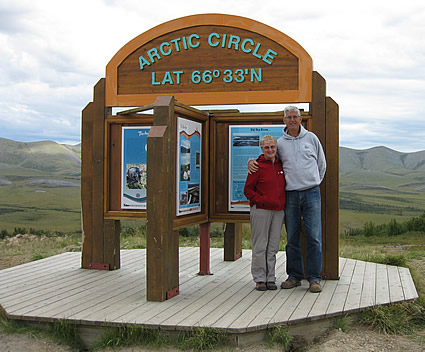
The thrill of reaching the Arctic Circle prompted a ceremonial jig before we studied the detailed interpretive display. After a night at Rock River campground at kilometre 446, we crossed into the Northwest Territories, where we marvelled at a herd of 100 caribou across the tundra.
While negotiating the free Peel River cable ferry crossing, we noticed the truck canopy's rear window was shattered. A rock must have bounced off the front of the trailer, but good old duct tape came to the rescue. The trees were larger and the landscape flatter as we descended into the Mackenzie Delta.
After taking another ferry across the mighty Mackenzie, we were soon in Inuvik, a community of 3,500 overlooking the maze of lakes and streams of the Delta and a staging area for energy exploration of the Beaufort Sea. The temperature was still in the low 20s when we checked into the Happy Valley Territorial Campground and enjoyed a welcome shower.
Wrapping up the journey
Even though it was August 19, the sun set around midnight and it was never really dark. We explored the town, curious about the deep piles into the permafrost holding up every building and the above-ground servicing pipelines.
On our return, we shopped in a small store at Fort McPherson, about 200 kilometres south of Inuvik.
“You’re at the mall,” joked one of the locals.
Wetter weather made the journey back more challenging, but we survived without anything worse than a few screws in the trailer shaking loose. The truck and the trailer definitely had that mud-covered, Dempster Highway look when we arrived in Whitehorse.
We could wash the mud off. The brilliant memories won’t be so easily erased.


