Land of the standing-up rocks
Chiricahua National Monument is a wonder to behold

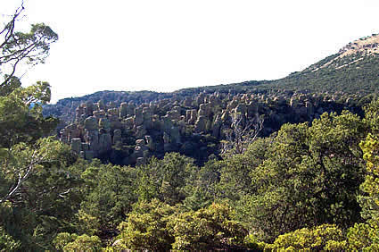
The Chiricahua Apaches knew this place as “Land of the Standing-up Rocks” and the early pioneers named it “Wonderland of Rocks.” Today many think of it as a “Fantasy World.” The mountain itself is one of the 12 “Sky Islands” of the Coronado National Forest.
Chiricahua is pronounced cheer-I-cow-ah. It is an Opata word meaning wild turkey. The term Sky Island was created to describe a mountain rising up from a sea of grasslands that contains plants and animals from four ecosystems. The Rocky Mountains, Sierra Madre, Sonoran and Chiricahua deserts meet here. Geologists believe these formations began as ash that resulted from the Turkey Creek volcanic eruption that cooled and fused into rhyolite 27 million years ago. Wind, water, ice and time sculpted the solid mass into huge towers and then further shaped them by erosion into one of the greatest rock formations on earth. China Boy and Organ Pipes were chiseled into being during the erosive time. Bonita Canyon, named for the wife of a scout from Fort Bowie, was created in what is now Apache Pass.
This is a rich, diverse treasure land of vegetative types. The area is cool and moist with forests and numerous species that migrated from Mexico. Birders flock here to observe such beauties as the elegant trogon (summer), magnificent hummingbird (rare) and hepatic tanager (rare). The area has been classified as an Audubon Important Bird Area. Photographers will find Mexican mammals living amongst the animals common to the southwest. There are bear, mountain lion, jaguar, Apache fox squirrels, coatimundi, Coues white-tailed deer, the northern pygmy mouse and western box turtles here. Many trees and wildflowers have found their way up from Mexico. The cliffs of the South Fork area are pocked with caves and a visitor with the slightest bit of imagination can almost see prehistoric man moving among the caves.
The road into the area leads first to the resting place of the first European settlers, the Erickson family. They came in the 19th century and called their place Faraway Ranch. The buildings are still standing and open to the public. The story of this family’s immigration is inspiring. They were the ones who promoted the idea of creating a national park here. Further along the road is the Visitor’s Center where you can view an eight-minute video. The shop contains many books and brochures to help both the casual and the specific explorer get the most from their visit. Continuing on the road for eight miles will bring the traveller to the crest of the mountain, Massai Point, named for the Apache Indian who stole Colonel Stafford’s horse and left his footprint on the trail. You can stretch your legs here and follow the trail to the top to see the desert valleys, Sugarloaf Mountain and Cochise Head, just as the first white man did while tracking Bigfoot Massai. The elevation at Massai Point, 6,870 feet, makes the air crisp and clear and campers should be aware of altitude sickness and pace themselves accordingly. It helps to drink plenty of water and one should also take water on the trail. There are more than 20 miles of trail ranging from a quarter mile to nine miles. The Civilian Conservation Corps took six years to build some of the trails, buildings, telephone lines and the sewer system.
A year-round campground operates on a no-reservation basis, having tables, grills, restrooms and water. It will accommodate tents and trailers up to 26 feet long. The campground is set in the shade and is quite beautiful.
Side trips from the Chiricahua National Monument include the Cochise Stronghold, believed to be the home and burial place of the legendary Apache, Cochise. Trails, picnic tables and campgrounds are available here. The Amerind Foundation, a private, non-profit organization, operates an anthropological and archeological museum. They sometimes have speakers. Amerind is derived from American Indian. Both of these sites are in the Dragoon Mountains.


